Big Bend National Park is located on the Rio Grande River in one of the most remote corners of America. We spent three and a half days exploring its canyons, deserts, and mountains. Floating down the Rio Grande on our last day in the park was a memorable experience and the highlight of our trip.

Park History
Spanish explorers called the area “El Despoblado,” or “unhabitable land,” but after Texas became part of the United States ranchers like Sam Nail and Homer Wilson raised cattle and sheep here. The growing popularity of national parks across America led local Sheriff E. E. Townsend and entrepreneur J. O. Langford to pitch the idea of a creating a national park in Texas to Amon Carter, the publisher of the Fort Worth Star Telegram. Langford owned the small resort at Big Bend’s hot springs and hoped to increase tourism by creation of the park. The idea for the park caught on and in 1942, the Texas legislature allocated $1.5 million dollars to purchase land for the park. The land was deeded to the United States in 1943, and the park was formally established on June 12, 1944 – in the middle of the Second Word War. After the park’s creation, the Civilian Conservation Corp descended on Texas to build roads and trails through the park. Thanks to conservation efforts the natural desert habitat is recovering from years of serving as ranch land. Today, Big Bend is an International Biosphere Preserve because it is a prominent example of a Chihuahuan Desert ecosystem.

Fossil Discovery Exhibit
We arrived at Big Bend in the middle of the afternoon. Our first stop was at the Fossil Discovery Exhibit. The Exhibit was established in 1957 by John Wilson, a paleontologist from the University of Texas. Instead of excavating and removing the fossils of small, horse-like mammals discovered on this site, Wilson decided to display the fossils as they occurred in the rock formation. A small building was built over the rocks and became a popular stop along US-385 for park guests. In 2016, the Fossil Discovery Exhibit replaced the small shelter over the fossils and gives park visitors a more complete picture of Big Bend’s prehistoric past.


The site is essentially an open air museum that houses fossils from dinosaurs and ancient mammals that lived in the Big Bend region. The Tyrannosaurus Rex fossils might be the most popular fossils on display, but we were impressed with the massive femur of an Alamosaurus! The Fossil Discovery Exhibit is a great introduction to the park’s geologic history as well. We were surprised to learn that the Chisos Mountains were once a massive volcano during the Eocene, 35 million years ago.


Chisos Mountains
After visiting the Fossil Discovery Exhibit, we made our way up the Chisos Mountains. The Chisos range is contained entirely within the park’s boundaries. We enjoyed the scenic drive to the top, but by the time we reached the parking area, it was late in day. We only managed to walk the short .3 mile Window View Trail, but it was a great place to see the sunset! Unfortunately, during the rest of our trip, poor weather at the top of the mountains prohibited us from returning. We will have to make a return trip to Big Bend to hike the famous Lost Mine Trail.


Boquillas Canyon
We started our second day in the park by driving to Boquillas Canyon near the park’s eastern boundary. Boqullias Canyon is one of Big Bend’s three major canyons on the Rio Grande. The trial into the canyon is about 1.5 miles round trip from the small parking area. The trail starts up a hill, then descends down to the river and into the canyon.


We arrived early enough that we essentially had the trail to ourselves, sharing it only with some stray horses and cattle that wondered across the river from Mexico. Following the horses into the canyon made for a memorable experience. In addition to the animals, hikers will find items made by crafters in nearby Boquillas del Carmen, Mexico, which is visible from several points along the trail. The crafts are labeled with a price tag and can be purchased upon the honor system – but be advised the U.S. Government considers these purchases illegal and Border Patrol agents may seize goods that were smuggled into the United States. Items scattered along the trail made this hike seem even more fun, but we didn’t make any purchases. A better way to make purchases is to visit Boqullias del Carmen. For more information on crossing the border visit the Park’s website.


Once inside the canyon, we were amazed by its beauty. The canyon’s limestone walls reach up to 1,500 feet, and the morning sun and shadows displayed a wide array of colors. Butterflies were abundant on the trail inside the canyon. We enjoyed spending time with them in the cool canyon out of the hot West Texas sun.

Boquillas Canyon to Panther Junction
Our first stop after Boquillas Canyon was at the Rio Grande Village Nature Trail. The trail begins at campsite #18. It is only a .75 mile loop. The first 100 yards is accessible boardwalk that leads to.a wetland environment. The trail passes mortars carved into the stone by Native Americans, which were used to grind corn and grains. After the boardwalk ends, the trail climbs a hill that provides views of the river, the Chisos Mountains, and the Sierra Del Carmen Mountains.


The Hot Springs Loop Trail is one of the most popular hikes in the park. The road to the trailhead is a little rough, but manageable. The nearly one mile loop leads by the Hot Springs and Langford’s abandon resort. Flakey shale rocks that contain fossils make the trail interesting. The water in the spring is 105 degrees. The ruins of Langford’s spring house provide a place to sit around the edge of the hot spring. We especially liked the view of the Chisos from this trail. Also watch for petroglyphs high on the rocks near the ruins of Langford’s motel. Be advised that there is no shade on this trail!


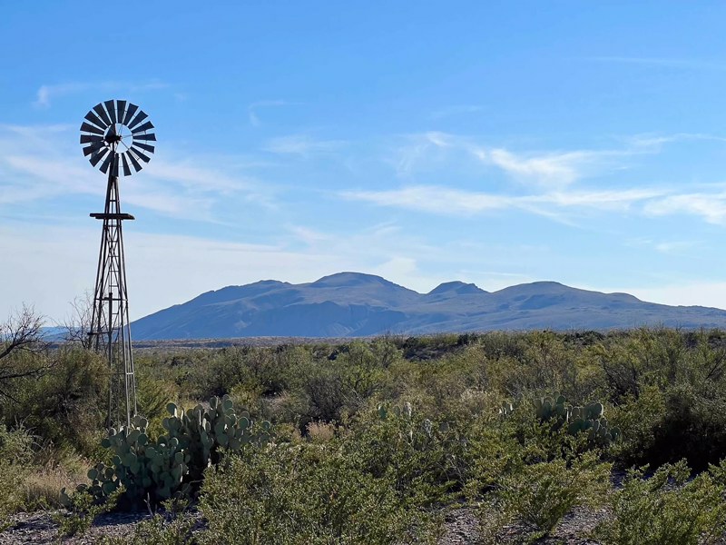
Our favorite stop between Boquillas Canyon and Panther Junction was Dugout Wells and the Chihuahuan Desert Nature Trail. The nature trial is an easy .5 mile loop through cacti and desert plants. Placards label different species – we were interested to learn that there are three types of prickly pear in the Chihuahuan Desert. Dugout Wells was once a cultural center for ranchers in the region. The wind mill still actively pumps ground water creating a small oasis.
We appreciated the rangers at the Panther Junction Visitors Center providing information about other areas of the park. There is a small nature trail behind the visitors center. Gasoline is available at Panther Junction as well.
Ross Maxwell Scenic Drive
The Ross Maxwell Scenic Drive begins just west of Panther Junction and ends at the spectacular Santa Elena Canyon. There are many scenic overlooks and hiking trails along the drive. The first stop along the scenic drive is the Sam Nail Ranch where the working windmill provides water for beautiful agave and sotol plants.


The Blue Creek Ranch Overlook provides a view of Homer Wilson’s sheep ranching headquarters and serves as the trailhead for several trails through the desert.


On a clear day, Santa Elena Canon is visible from the the top of Sotol Vista, but clouds and fog covered the desert during our visit. We enjoyed the view from Mules Ears Viewpoint instead. The distinctive peaks are one of our favorite features in the park.

A half mile trail leads to the Lower Burro Mesa Pouroff, a dry waterfall inside a hidden box canyon.

Our favorite stop on the Ross Maxwell Scenic Drive was at Tuff Canyon. There are three viewpoints atop the canyon and a .75 mile trail that leads through it. The canyon is named for the white Tuff, or welded volcanic ash, that coats the sides of the canyon.


The Castolon Historic District was once the headquarters of the La Harmonia Company. Today, there is a small visitors center and general store at the district, but a 2019 fire wiped out many of the historic buildings.

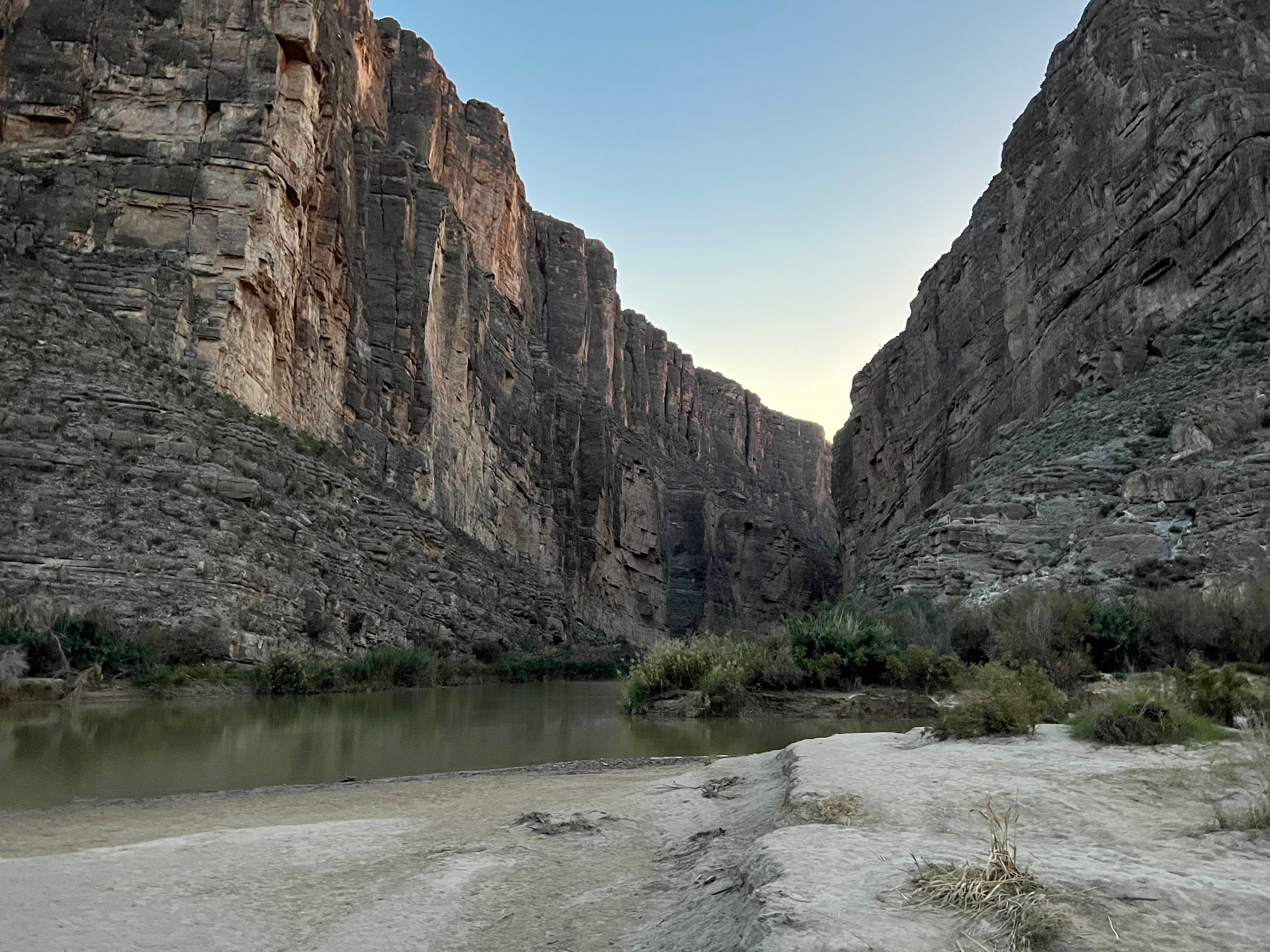
Santa Elena Canyon
Santa Elena Canyon lies at the end of the Ross Maxwell Scenic Drive. It features sheer 1,500 limestone cliffs. A 1.7 mile trail leads into the stunning canyon. As a result of rains during our trip, the trail was a little more difficult due to high water in Terlingua Creek. After crossing the creek, the trail ascends up the right wall of the canyon. As we hiked back out of the canyon, we enjoyed the pink sunset – one of our favorite experiences in Big Bend National Park!


Canyon Float Trip
On our last day in the Big Bend region, we took a canyon float trip with Big Bend Boating and Hiking Company. We opted for a full day trip. On full day trip, guests meet at Big Bend Boating and Hiking Company’s office in Terlingua to get outfitted with gear: personal floatation devices and rubber boots. The company determines which canyon, you’ll float based on water levels. We were taken to Colorado Canyon in Big Bend Ranch State Park for our trip. The drive through Big Bend Ranch State Park includes the steepest road in Texas. Unlike Boquillas or Santa Elena Canyons, Colorado Canyon was formed by volcanic activity, so its walls are made of dark volcanic rock.

We had an awesome guide for our raft trip! She explained the history of the area, pointed out wildlife, and discussed conservation efforts with our group as she paddled us down the river. The views of the canyon from the river are stunning! We are so glad we took this trip.


Vivá Terlingua!
We stayed in Terlingua, Texas. Terlingua was once a booming mining town where miners worked in teams of two to dig cinnabar out the ground. Cinnabar is a rock that contains mercury. Terlingua’s mercury was used to make bombs during the World War I. With advancements in weaponry and knowledge of the dangers of mercury poisoning, the mines eventually closed leaving behind the Terlingua Ghost Town, which is an interesting place to explore in its own right.


While there are many vacation rentals in the ghost town itself, we stayed at a nice AirBnb just up the road. Molly’s cute cabin was perfect for us! We loved the native desert plants surrounding the cabin and viewing the stars at night.

Terlingua has limited restaurant options, but we didn’t have a bad meal during our stay. The only real breakfast option is Expresso v Poco Más. Each morning, you’ll find locals and national park visitors lined up for breakfast burritos and coffee at this unique little spot.

After breakfast, the Expresso y Poco Más crew moves over to Taqueria El Milagro to serve lunch and dinner. The tacos are delicious, but our favorite thing on the menu were the quesadillas!

We also enjoyed authentic Texas barbecue at D.B.’s Rustic Iron Barbecue. D.B.’s brisket tacos were amazing!

Longdraw Pizza offers several unique combinations named for the Big Bend region. We enjoyed a large “Big Bend” after our river trip!

If you enjoyed this post, please check out our other blogs at landofliberyexplorers.com and follow us on Facebook or Pinterest!
Interested in visiting more National Parks Service sites in the Lone Star State? Check out these posts:
Guadalupe Mountains National Park
Fort Davis National Historic Site


